 |
|
|
|
|
Produced by the Red Lake County Historical Society, Red Lake Falls, MN.
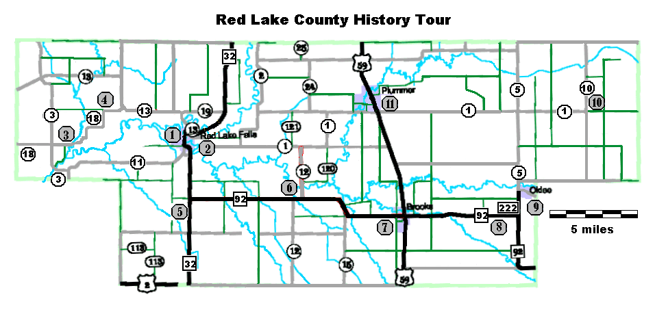
Maps can be found at the end of the tour. To print maps separately CLICK HERE.
|
Western Tour |
Eastern Tour |
|
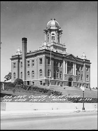
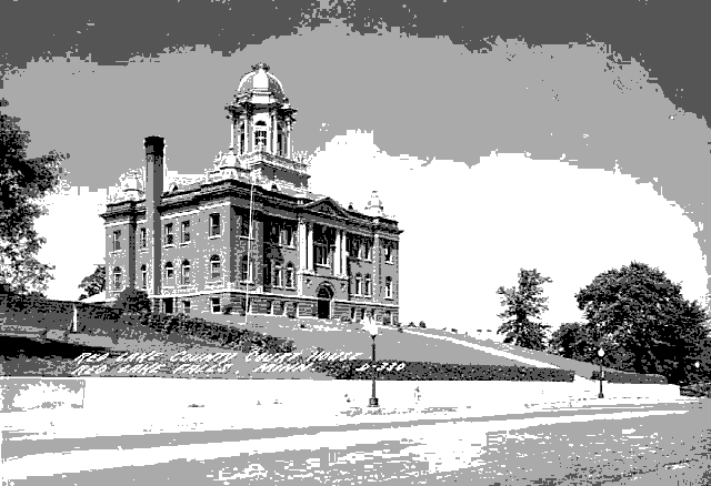
1A. Red Lake County Court House 3A. The "Old Crossing" and the Pembina Trail |
9A. Former home of Coya Knutson |
A History Driving Tour of
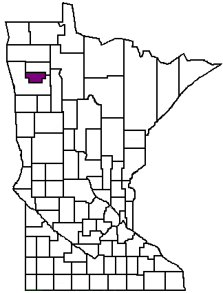
RED LAKE COUNTY, Minnesota
|
|
Red Lake County, Minnesota, has a rich and varied history in which the Red Lake and Clearwater Rivers have played a central role. These rivers provided the proper habitat for a wide range of wildlife. Over two hundred years ago this wildlife attracted the Chippewa (Ojibwa) Indians who were following the fur trade business west from the great lakes region. By 1798 Jean Baptiste Cadotte had established a trading post near the junction of the two rivers in or near the present day Sportsman's Park in Red Lake Falls. As oxcarts began crossing the area while transporting goods between St. Paul, Minnesota to the south, and the Selkirk or Red River Colony (present day Winnipeg, Manitoba, Canada) to the north, the "Old Crossing" of the Red Lake River near Huot, Minnesota, became a place of historical importance. At the Old Crossing in 1863 a peace treaty was signed between the Red Lake and Pembina bands of the Chippewa Indians, and the U.S. Government. This treaty ceded to the United States nearly 11 million acres of some of the most fertile land in the world. In 1876 Pierre Bottineau, the famous Metis (of mixed French and American Indian blood) guide, brought the first settlers to the area, 119 families of French Canadian descent who founded the towns of Red Lake Falls and Gentilly. Settlers of European descent followed, attracted to the same waters that attracted the Indians and trappers before them. Newspapers of the time advertised the abundant supply of waterpower provided by the two rivers. |
These same waters still maintain their powers of attraction as vacationers come each summer to enjoy the beautiful scenery while floating in inner tubes on the Red Lake River.
As more settlers arrived many towns were established to serve the farmers or to make use of the county's waterpower. Few of these still survive today. Only those established along the railroad routes saw the dawn of the twenty-first century.
This self-tour is divided into two parts Western Red Lake County and Eastern Red Lake County. Each part will take two to four hours and will cover approximately 20 (western) to 45 (eastern) miles designed to introduce you to the diverse and interesting history of the area. Relax and enjoy the beauty of the area as you journey into the past.
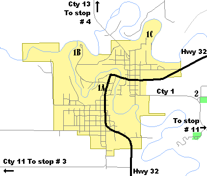
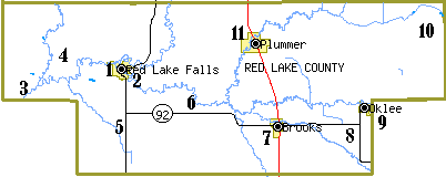
Tour Stops (see map at end of tour):1A. Red Lake County Court House
1B. Cadotte Trading Post Site - Sportsmen's Park
1C. Water Power - Old Power Dam Site
The area of the natural confluence of the Red Lake and Clearwater Rivers has a long history of human habitation. Long before the first white explorers and fur traders came to the area, this river crossroads was a favored Indian camp and village site.
During the 18th century, European explorers found their way into what became northwestern Minnesota, and in 1794 Jean Baptiste Cadotte, Jr., established a fur trading post here for the British Northwest Co. Subsequently, the country came under the American flag and the British traders left. It was not until the Old Crossing Treaty was signed with the Red Lake and Pembina bands of the Chippewa Indians in 1863 that the Red River Valley was opened for settlement. Among the earliest settlers were several French Canadian families in 1876. During the 1880’s and 1890’s numerous Scandinavian and German immigrant farmers came to the region.
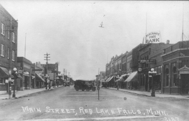
Red Lake Falls, incorporated as a village in 1881 and as a city in 1897, became the county seat of the new Red Lake County established Dec. 24, 1896, in a separation from Polk County.
Large lumbering operations occurred in Red Lake Falls until 1911, but farming soon became the premier economic activity. Small tract farming was followed by the opening of large grain farms, and a sizable milling industry grew out of the farming pursuits because of the waterpower available from the river rapids and falls. Red Lake Falls was at the forefront in the water powered industrial movement.
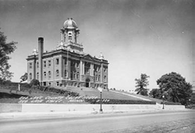
The battle to form Red Lake County, followed by the fight to name Red Lake Falls rather than Thief River Falls as the county seat, provides an insightful look into pioneer politics in Minnesota. Red Lake County was carved from Polk County in 1896. This courthouse was built in 1910 just as Thief River Falls was successfully fighting to form its own county (Pennington).
The building once had a large central dome that was removed in 1947 because it had taken a tremendous beating from the elements resulting in serious leakage.
The courthouse is significant for its central role in the affairs of Red Lake County and for its distinctive style and location. Its hilltop setting and its good integrity make it the most imposing building in the county. It was for these reasons that the courthouse was entered into the National Register of Historic Places in May 1983. Please walk in and take a look around (enter from the east). A replica of the Statue of Liberty, once housed in the Courthouse dome, is now on display in the rotunda.
Jean Baptist Cadotte Jr., an employee of the Northwest Fur Trading Company, erected the first trading post in the area near this site, at the junction of the Red Lake and Clearwater Rivers. (The actual site is unknown but believed to be across the Clearwater River from The Al Buse Sportsman's Park.) We know that Cadotte spent the winter of 1797-98 here from the writings of David Thompson, a geographer and surveyor who took shelter in the cabin during a spring snow storm (1798). Thompson wrote: "Mr. Baptiste Cadotte was about thirty-five years of age. He was the son of a French gentleman by a native woman, and married to a very handsome native woman, also the daughter of a Frenchman. He has been well educated in Lower Canada and spoke fluently his native language with Latin, French and English". Codotte Jr. is given credit for completely opening to the fur traders the region north of the upper Mississippi.
The waterpower furnished by the Red Lake and Clearwater rivers has been described by writers of that day as second to none in the northwest.
The Gazette in 1897 reported: "Not even the famous falls of St. Anthony can eclipse the power capable of being furnished by the natural combined power of the Clearwater and Red Lake rivers. Experts have estimated the total possibilities of these water powers, when developed to their highest, as 10,000 horsepower. The advantages Red Lake County offers for the locations of manufacturers discount anything to be found in the northwest."
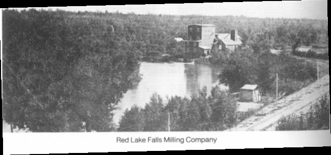
The Northside Milling Company was erected by Carl Kretschmar about 1882 at the site on the Red Lake River northeast of Red Lake Falls.
In 1885 this business became the Red Lake Falls Milling Co. owned by Johnson and Marshall who manufactured "Mascot" and "Favorite" brands sold mostly to the eastern markets and Europe. The company owned 12 elevators, all of which sold the mill's flour. The mill had a capacity of 1,000 barrels daily and also operated a cooper shop where the barrels used by the mill were made. It is believed the mill was in operation as late as 1912.
Park and Walk . . .
You may park in the small lot next to the paved bicycle/snowmobile trail and walk out on the old railroad bridge. The old mill race is now filled in, but it would have been to your left as you walk to the bridge. The remains of the dam can still be seen just downstream of the bridge.
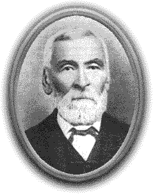
If any one person stands out in the early history of Red Lake County it is Pierre Bottineau. Born in 1817 in Red River country he was the son of a French man and a Chippewa woman. He learned the ways of the woods and prairies while a child trapping with his voyageur father.
Fluent in French, English, Chippewa, Cree, Mandan, and Winnebago, Bottineau worked for various agencies as interpreter and guide. In 1876 he, and two of his sons, came to what is now Red Lake Falls and staked a claim along the Clearwater River. He encouraged many French Canadians from St. Paul, Minnesota and the Red River Colony (Winnipeg, Manitoba, Canada) areas to settle here. He died in 1895 and was buried in the Cyr Cemetery west of Red Lake Falls. In 1978 the Red Lake County Historical Society moved his remains, and those of four members of his family, to this site.
The Pierre Bottineau Memorial at the entrance of St. Joseph's Cemetery in Red Lake Falls was dedicated in August 2000. Susan Warner, a potter and ceramist of Minneapolis, was awarded the commission, and completed the project that was funded by the Minnesota State Legislature.
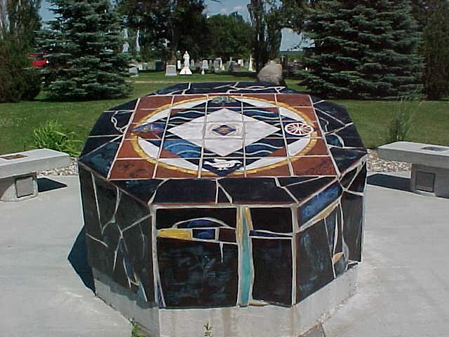
The structure is 6 feet in diameter with a slanted face covered with colorful tiles depicting the life of the famous and trusted Metis guide with scenes of early expeditions into territories that brought frontier settlements and industry into Minnesota and the Dakotas.
The establishment of a permanent monument to Pierre Bottineau at his gravesite creates a place for reflection and education, and shows a gratitude for his years of distinguished service as a founding father and civic leader.
While on your way to stop #3 . . . . .
While on your way to stop #3 you will pass the Cyr Cemetery, the original burial place of Bottineau and his family. It is just north (right) of Hwy 11 about three miles from Red Lake Falls.
STOP # 3: THE OLD CROSSING TREATY PARK
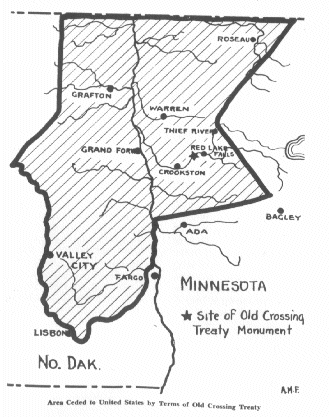
This area of Louisville Township has a great deal of historical interest dating back to the 1830's when ox carts forded the Red Lake River transporting goods and furs from the Red River Colony and Pembina, Canada, to St. Paul and beyond. It was here that the Old Crossing Treaty of 1863 ceded 11 million acres of fertile land to the United States Government.
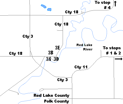
STOPS: (See map at end of tour.)3A. The "Old Crossing" and the Pembina (Ox Cart) Trail
3B. Shrine of the Blessed Virgin
3C. Post Office Tree
3D. Old Crossing Treaty Memorial
3E. Huot and Louisville Township
This park is located on the site of the Old Crossing, where from 1844 to the 1870s thousands of ox- drawn two wheel carts crossed the Red Lake River here while hauling goods between St. Paul, Minnesota, and the Red River Colony (Winnipeg, Manitoba, Canada). This particular trail became known as the "Woods Trail" because of the forested areas south of present day Detroit Lakes through which it passed, but is known locally as the Pembina Trail. The Woods Trail, which passed entirely through lands once controlled by the Chippewa Indians, became popular to oxcart drivers when the more westerly trail, along the Red River in North Dakota, came under attack by the Dakota Sioux Indians.
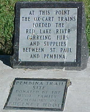
This marker is on the site of the Woods (Pembina) Oxcart Trail. If you can brave the mosquitoes, you can see the indentation of the actual trail through the woods ahead of you.
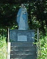
Across the road from the county park is a shrine built by Father Ernest Bossus, pastor of St. Dorothy's Catholic Church from 1926 to 1935. The roots of St. Dorothy's Parish go back to the Huot area, where Father Pierre Champagne offered mass at the home of Louis Huot as early as 1880.
At that time there were about 25 Canadian families located in the area. A church, St. Aloysius, was built at Huot in 1883. In 1919 a new church was built in the village of Dorothy (5 miles north) and the St. Aloysius Church was closed. Father Bossus' sight failed in his last years at Dorothy but his eyesight was successfully restored by a cataract operation. In thanksgiving, he built a shrine in honor of the Blessed Virgin on this knoll across the road from Huot State Park. Dorothy's parishioners still gather annually for services at the Shrine.
Within the Old Crossing and Treaty County Park, along the river just north of the boat ramp, was a large Cottonwood tree, which was once used as a post office for early settlers. Oxcart drivers would collect or deposit letters in a box nailed to the tree as they passed through the area. The "Old Crossing" of the Red Lake River was near this tree. In August of 2001 a one hundred mile per hour wind topped the tree leaving just a large stump.
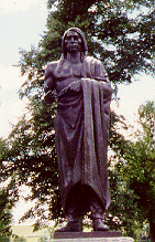
The Old Crossing Treaty memorial, a bronze life-size figure of a Chippewa Indian holding a peace pipe, was erected in 1932 by the U.S. government to commemorate the signing of a peace treaty with the Chippewa Indians in 1863.
Representing the U.S. government at the treaty talks was Alexander Ramsey, Minnesota's first Territorial Governor, who came from St. Paul escorted by a small detachment of U.S. soldiers. When Ramsey reached the Old Crossing, the Red Lake band of Chippewa were already there with their chiefs Mons-o-Mo, May-dwa-gun-on-ind, Little Rock, Broken Arm, and Leading Feather. Two days later the Pembina band arrived with Red Bear of Pembina and Little Chief of Turtle Mountain as their leaders.
After two weeks of negotiations the Chippewa ceded an area approximately 180 miles from north to south, and 127 miles from east to west, containing approximately 11,000,000 acres (see map on next page). For this land the United States paid $510,000.
Article One of the treaty reads as follows: "The peace and friendship now existing between the United States and Red Lake and Pembina bands of the Chippewa Indians shall be perpetual ".
Just north of the park along the Red Lake River was the village of Huot. On January 7, 1879, commissioners of Polk County created the Louisville Township, and named it for Louis Huot, an early settler who had founded the Village of Huot on the banks of the Red Lake River.
From its beginning, Huot was a thriving community. There was the St. Aloysius Catholic Church, J. R. Huot owned the general store, Charley Huot was the local blacksmith, and Peter LaChance the creamery operator.
In the early 1880's a ferry operated on the Red Lake River charging a fee for moving wagons and people across the water by use of a winch. A bridge across the Red Lake River at Huot was not built until the early 1900’s and served until 1966 when high waters and ice tore the rotted timbers from their moorings and it collapsed. In 1983 the present new bridge was finally built one mile down stream on County Rd. #3.
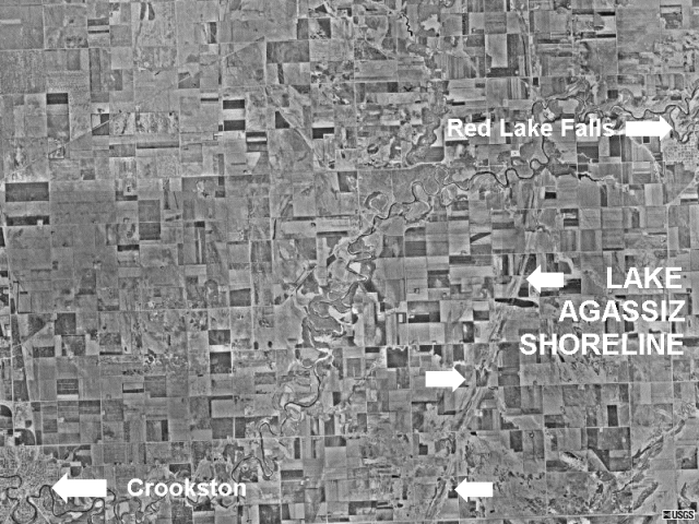
STOP # 4: GLACIAL LAKE AGASSIZ SHORELINE
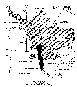
The ridge ahead of you (looking east) was once the shoreline of a large body of water known as Lake Agassiz. Over 10,000 years ago glaciers extended as far south as Iowa. As they receded, Lake Agassiz was formed when runoff from the melting glaciers was blocked to the north by the glacier. (All rivers in this area drain into the Red River then north to the Hudson Bay.) This shoreline ridge can be clearly seen on satellite photographs of the area.
Lake Agassiz was huge, extending from well into Canada, as far south as present day Breckenridge, Minnesota, and east past Upper and Lower Red Lake. Water from this lake drained to the south via Glacial River Warren through whose valley flows the present day Minnesota River. The several successive levels of Lake Agassiz are recorded by distinct and approximately parallel sand ridges indicating the ancient shorelines. Some of these ridges provided excellent natural roadways for the Red River oxcarts.
On your way back to Red Lake Falls . . .
Just before you enter Red Lake Falls you will cross the Red Lake River. During the summer months thousands of vacationers rent inner tubes and enjoy the cool water and beautiful cliffs while floating down the river.
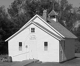
The Perrault School, District #32, was one of six in Lake Pleasant Township of Red Lake County. Classes were taught here for 68 years from 1880 to 1948 when the district was consolidated with that of Red Lake Falls. In 1901 District #32 had Josephine Kaus as a teacher with thirty-one students. Her salary was $30.00 per month. The school building has served as the Lake Pleasant Town Hall since 1881. The schoolhouse has been restored as an interpretive center for early American schools.
While Driving . . .
Several former one-room schoolhouses can be seen along this history tour. Some are used as township halls (see stop # 8), others for storage, and others are no longer used. Look for them as you drive.
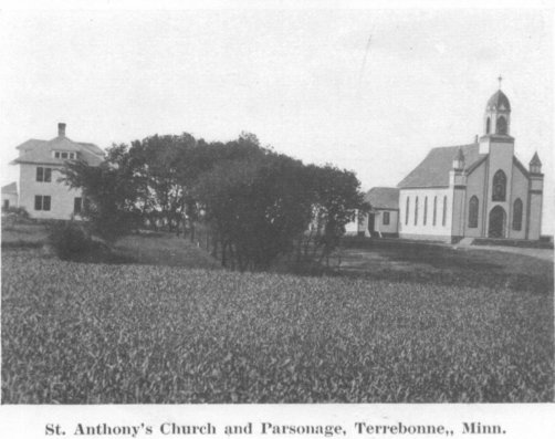
Strikingly located on a small rise along Highway 92, six miles east of Red Lake Falls, is the Church of St. Anthony of Padua with a cemetery and two beautiful shrines illuminated at night.
French Canadians from Montreal, Canada, founded Terrebonne in the spring of 1879. Fifty-three tickets were purchased for this journey, some of the families settling near Gentilly and some in Terrebonne. At that time there were no other settlers, Native or European, around the Terrebonne area.
Father Pierre Champagne of Red Lake Falls established a mission here in 1879 with masses said in pioneer homes. In 1882 he built the first church on a ten-acre plot given by the Louis Cadieux family. Several priests served the parish until Father W. T. Roy came in 1892 and by 1895 the parish was prosperous enough to build a new and larger church with improvements and decorations made in subsequent years.
The two outdoor shrines, one in honor of the Sacred Heart and the other of the Blessed Mother and St. Bernadette, were erected and donated by Father Samuel Bouchard who came in 1922 and stayed until 1930. Father Ernest Paquin came that year and remained until 1955, followed by Father Louis Proulx until 1969 when Terrebonne became a mission church. Because of declining population and the shortage of priests in the Crookston diocese, the Church of St. Anthony was closed in the year 2000.
The Terrebonne Milling Company served the farmers of Red Lake County from 1884 to the big fire on July 4, 1954, a period of 70 years. In 1884 Hanibal Ames built a roller mill on the Clearwater River just north of Terrebonne. The mill burned in 1887 and again in 1915. The three story high mill received it power from a dam constructed of rock and crib work, about 175 feet wide.
Competition from the large milling companies following World War II brought a decline in the need for the smaller local mills. Thus, when a spectacular fire on the night of July 4, 1954, leveled the Terrebonne Mill, it signaled an end to a business made obsolete by time and progress.
Drive to the river . . .
To see the Clearwater River near the mill site continue east on Hwy 92 just a few hundred feet, turn north (left) on Cty 12 and drive to the bridge.
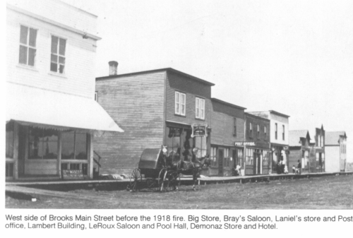
At the intersection of U.S. Hwy 59 and MN Hwy 92 a sign states: “BROOKS - Largest Little City in Red Lake County”.
Homesteaders, 90% French Canadians, had come to Popular river Township and organized in 1884. With the coming of the Soo Line Railroad in 1904 the first buildings were erected and Brooks became a prosperous little farming community with two general merchandise stores, a bank, hardware store, butcher shop, blacksmith shop, livery barn, lumber yard, two saloons, and a hotel. Sadly, a fire in 1918 wiped out half of the businesses.
The Brooks Cheese Factory was built by the Aurelius J. Parenteau family in 1926 and operated until 1980 producing quality cheddar cheese and remembered for its famous cheese curds.
St. Joseph’s Catholic Church celebrated its first mass in Brooks on Dec. 31, 1916. In 1933 the Rev. Louis E. Proulx came to the parish where he served for 22 years. Father Henry Carriere followed him in 1955. The present church was built in 1957. St. Joseph’s is now a mission parish of St. Joseph’s Catholic Church in Red Lake Falls.
Alfonse F. Lambert and wife, Cesarie, of Quebec, Canada, came to Lambert Township, Polk County, in 1881. Here they built their home in what was to become the Village of Lambert. He assisted in the organization of the new township that bears his name and was a leader in founding St. Francis Xavier Catholic Church (see stop 9B). At one time the village had the church, a hotel, a blacksmith shop, a post office, four stores, and several homes.
The present Lambert Town Hall along Hwy 92 was built as schoolhouse in 1882 and used until 1904. The first teacher was Agnes Monpetit. The building is still in its original location.
Visit the Cemetery . . .
The French and Norwegian heritage of the area is clearly seen in the cemetery headstones a block south of the town hall.
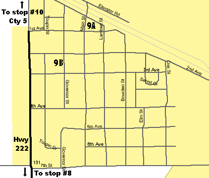
STOPS (see map at end of tour.)
9A. Former home of Coya Knutson
9B. St. Francis Xavier Church
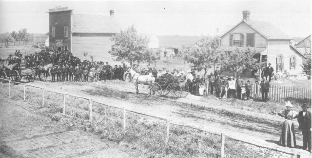
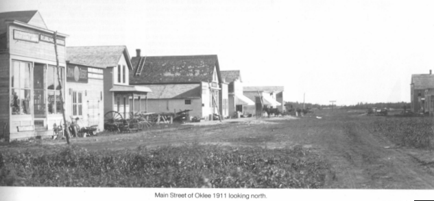
When the Soo Line Railroad was built in 1904 towns began springing up along the tracks to make use of the new transportation facilities. Oklee was such a town. The small village of Lambert, one and a half miles west of present Oklee had been in existence for several years but it was more that a mile from the railroad. An enterprising man named O.K. Lee, who dealt in real estate, sold some of the Lambert businessmen on the advantages of being closer to the railroad and thus created the birth of Oklee, so named in honor of the owner of the land.
Many of the businesses of Lambert moved their buildings to Oklee. Even the St. Francis Xavier Church was moved into town. Before long, many homes and businesses sprang up and in a short time Oklee was a busy town.
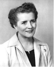
In 1950 Mrs. Coya Knutson, a high school instructor in Oklee and the wife of a local farmer and hotel operator, was elected to the state legislature where she served the people of the 65th District in Minnesota for three terms.
In 1956 she further distinguished herself, and focused attention on the town of Oklee, by becoming the first woman from the State of Minnesota to be elected to the Congress of the United States where she served for two terms in the House of Representatives
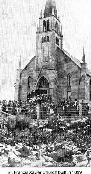
St. Francis Xavier Church was built in 1899 in Lambert Township under the pastor Father J. Archambault. The structure measured 40' X 90' and the cost was $3800.
In 1917 the church was moved to its present site at 301 Governor St. in Oklee. Major improvements were made when Father Charles Trudeau was the pastor from 1929 to 1932 including the installation of the beautiful stained glass windows at a cost of $75 each. Father Keough Patnode served as pastor from 1932 until 1952. Improvements during these years included a parish kitchen, a winter chapel, new pews, and a pipe organ. The new rectory was built in 1958 and in 1972 a new addition was built on the front of the church.
The Clearwater Evangelical Lutheran Church and the cemetery, 10 miles NE of Oklee, were both officially listed on the National Register of Historic Places on Nov. 18, 1999.
The church was organized with 30 members on Feb. 21, 1898, with the help of Rev. A. A. Oppergaard who stayed with the parish for seven years. The first services were held in homes and rural log schoolhouses until the present building was completed in 1912.
The church operated successfully until 1988 when it was closed due to reduced membership. Pastor Steven Sparley was the last pastor to serve the church.
In 1995 the Clearwater Heritage Association was formed for the purpose of preserving the past for the benefit of future generations, and to restore the church building to create even more awareness of the Norwegian heritage that was central to this rural area of Equality Township in Red Lake County.
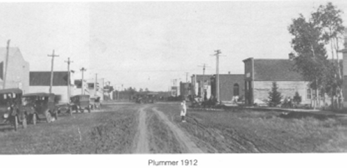
At the turn of the century the town site of Plummer was located west of the Clearwater River Dam. A man by the name of C. A. Plummer operated a feed mill and trading post which he later sold to H. H. Finrow. Finrow operated a store and restaurant and he was also the postmaster.
In 1904 the Soo Ste. Marie (Soo Line) Railroad built through Emardville Township of Red Lake County and a town soon began to mushroom close to the railroad east of Plummer. It was decided to call the new town Scotland, but upon petitioning it was found that there already was a Scotland in Minnesota. It was then named Plummer after the first storekeeper. The first freight train passed through town in September of 1904. Plummer was plotted in the summer and by the end of the year almost every business was represented.
If you are heading to Red Lake Falls . . .
If you are heading back to Red Lake Falls on Cty. Rd 1 you will come to tour stop #2, the Bottineau Memorial in about eleven miles.
MAPS
TOUR STOP #9: Oklee Tour Stops
TOUR STOP # 11: Plummer